How Historic Floods Reshape Rivers, Redistribute Gold, and Create New Prospecting Opportunities
⭐ PREMIUM ADD-ON TO THE GLACIAL GOLD FIELD GUIDE
Susquehanna River • Unadilla River • Chenango River • Mohawk River • NE PA Creeks
Compiled by ProspectingPA.com • July 2026 "Every flood is a gold shuffle. The river deals new cards. Your job is to read the new hand."
Why Floods Matter for Gold Prospectors
"Extreme high water events can dislodge gold from bedrock and place them
up in all kinds of odd locations." — GoldRushNuggets.com
Every major flood is a gold redistribution event. When a
river jumps its banks and scours its bed, everything gets shuffled — gravel
bars are rebuilt, bedrock cracks are flushed out, new channels are cut, and
gold that was trapped for decades or centuries is picked up and redeposited
in new locations. For a gold prospector, a flood is not just a disaster —
it's an opportunity.
THE FLOOD-GOLD PRINCIPLE
After a flooding event, new gold can be deposited into rivers and streams
if it was loosened by the flood outside of the banks and brought back into
the channel. The river reshuffles its gravel, exposes fresh bedrock, creates
new gravel bars, and deposits gold in new positions. Every major
flood resets the gold deposition pattern.
The Susquehanna River Basin is one of the most flood-prone watersheds in
the nation. The main stem has flooded 14 times since 1810 — about every 15
years on average. For gold prospectors working the Northeast, understanding
flood history is not optional — it's essential intelligence
that tells you where gold might have been recently redeposited.
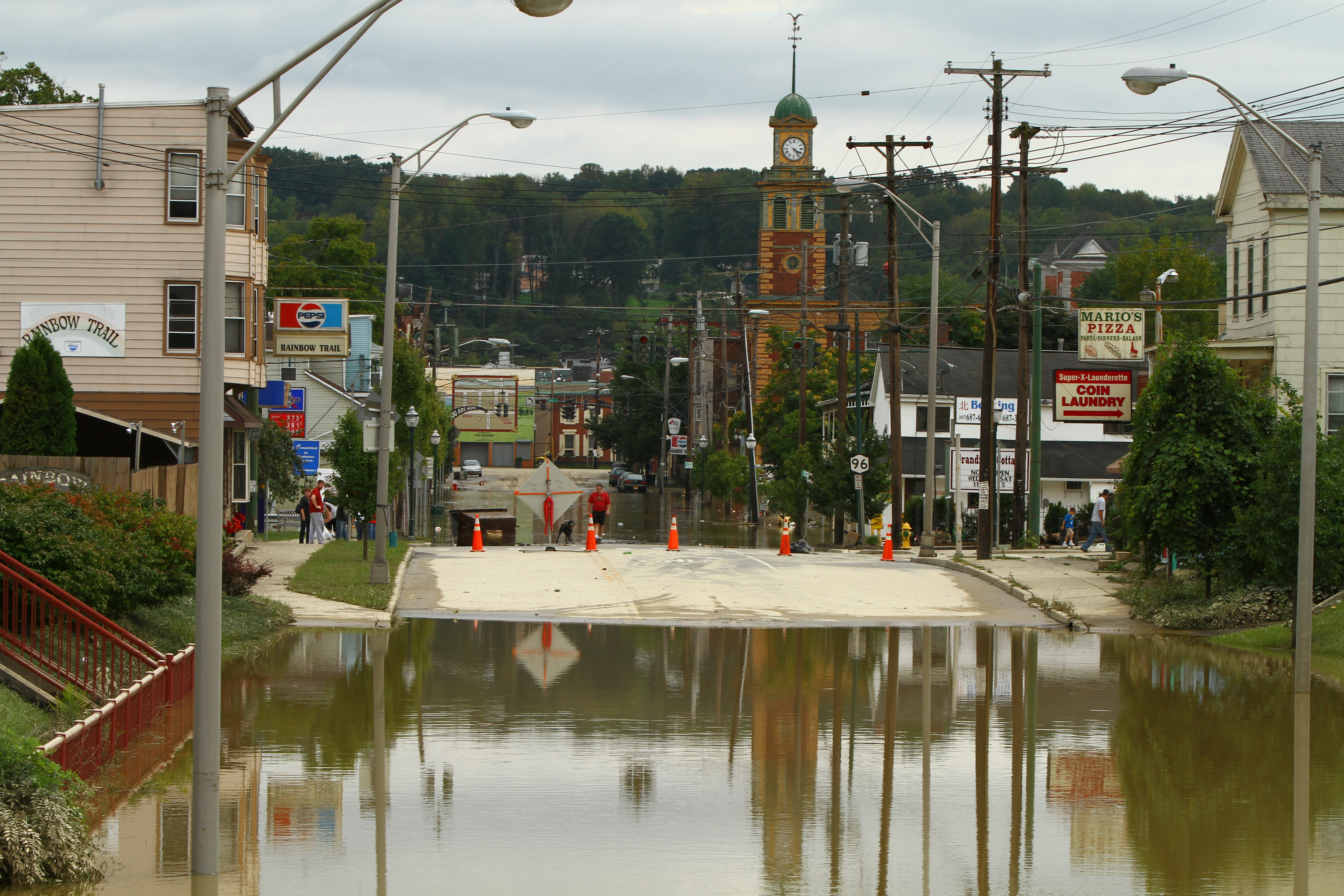
Owego, NY underwater during Tropical Storm Lee, September 2011. The Susquehanna River at Owego crested 1-4 feet higher than the 2006 record. This flood reshuffled gravel bars, flushed bedrock cracks, and redeposited gold throughout the river system. (Wikimedia Commons, CC BY 2.0, by Chris Waits)
What a Flood Does to a Riverbed
Scours bedrock cracks: High-velocity flood water blasts
out the gravel, sand, and gold trapped in bedrock crevices. Old gold is
picked up and carried downstream. Fresh bedrock is exposed for future
trapping.
Builds new gravel bars: As flood waters recede, they
drop gravel in new locations. New point bars form on inside bends. Old
bars are rebuilt or washed away entirely. Gold settles into these new
bars following the same physics — heavies deposit first at bar heads.
Cuts new channels: In extreme floods, rivers can
avulse — cut a new channel entirely, abandoning the old one. The old
channel becomes a gravel-filled depression that may contain rich gold
deposits that were never worked.
Erodes banks: Cut banks on the outside of bends are
eaten away, releasing bank-stored gold into the current. This gold is
immediately redeposited downstream in the next drop zone.
Deposits flood-layer gold: As flood waters overtop
banks, they spread out and slow down, dropping heavy materials including
gold on the floodplain. This "flood gold" can be found in thin layers on
the floodplain surface — sometimes far from the current river channel.
Creates new drop zones: Boulders moved by flood water
create new eddy zones. Trees washed into the river create new obstructions.
Every new obstruction is a new potential gold trap.
PROSPECTOR'S ADVANTAGE:
Most prospectors pan the same spots year after year. After a major flood,
those old spots may be dead — the gold has moved. But NEW spots that nobody
has ever panned are now loaded. The prospector who understands flood dynamics
has a massive advantage: they know to look where the flood DEPOSITED gold,
not where it USED to be.
Flood Physics & Gold Redistribution
How Flood Water Moves Gold
During a flood, water velocity increases dramatically. A creek that
normally runs at 2-3 feet per second can hit 10-15+ feet per second at
flood stage. This has profound effects on gold:
Normal flow: Gold stays trapped in bedrock cracks,
behind boulders, and in gravel bar heads. Fine gold is locked in place
by the constant gentle sorting action of the stream.
Flood flow: The massive increase in water velocity
overcomes the holding power of most gold traps. Gold is picked up and
carried as suspended load or bedload. Even large nuggets can be moved
by flood-stage water.
Flood recession: As the flood recedes and water
velocity drops, gold is redeposited following the same placer physics —
it drops where water slows. But the landscape has changed: new bars,
new boulders, new bedrock exposures. The gold lands in NEW traps.
The Flood Layer — Gold on the Floodplain
When a river overtops its banks, the water spreads out across the
floodplain and slows dramatically. This velocity drop causes heavy materials
— including gold — to settle out on the floodplain surface. This creates
thin "flood layers" of gold that can be found far from the current
river channel.
"Flood plain gold deposits" are recognized by experienced prospectors.
After a major flood, sample the floodplain surface — especially in natural
depressions, behind trees or rocks, and in the "bathtub ring" of heavy
materials deposited at the waterline as the flood receded.
Riverbank erosion — flood water eats away the cut bank on the outside of bends, releasing stored gold into the current. That gold is immediately redeposited downstream. (Wikimedia Commons, CC BY-SA)
Bank erosion exposing sediment layers. Flood events create visible layers in the bank stratigraphy. Gold can be trapped in these layers and released when the bank erodes. (Wikimedia Commons, CC BY-SA)
Channel Avulsion — When a River Finds a New Path
In extreme floods, a river can avulse — abandon its
channel and cut a new one. This is the most dramatic form of river change.
When avulsion happens:
The old channel becomes a gravel-filled oxbow or slough
Gold that was in the old channel is now stranded — still there but
in an abandoned watercourse
The new channel cuts through fresh ground, exposing new bedrock and
new gold-bearing gravel
The old channel can be a BONANZA — it's essentially a pre-worked
gravel deposit with gold still in it, but nobody thinks to pan there
because it's no longer part of the active river
Look for oxbow lakes, abandoned channels, and marshy depressions near
the current river. These are former river channels that may contain gold
deposits from before the channel shifted.
The Susquehanna River Basin has a long and violent flood history. Here
are the major floods that reshaped the rivers and creeks we prospect today:
1865
The Great Flood
One of the earliest recorded major floods on the Susquehanna.
A series of snowstorms followed by heavy rains caused catastrophic flooding
in the Wyoming Valley. Flood marks from 1786 and 1865 were later surpassed
by the 1889 flood. This flood set the early benchmark for Susquehanna
flooding and shaped the river channel for decades.
1889
The Year of Floods
Flood marks of 1786 and 1865 were surpassed. Buildings
built above the old water lines were swept away. This was the same year
as the infamous Johnstown Flood. The Susquehanna was radically reshaped.
1904
The Great Ice Jam Flood
An especially frigid winter froze the Susquehanna solid —
merchants crossed with horse-drawn freight wagons on the ice. When the
weather warmed, massive ice jams formed, backing up water and causing
catastrophic flooding when the jam released. Ice jam floods are particularly
violent because the ice SCOURS the riverbed more aggressively than water
alone — flushing gold from bedrock cracks more thoroughly.
1935 (July 8)
The NY State Flood
A devastating flash flood hit the Chenango and Susquehanna
River basins. Norwich and Oxford suffered $100,000 in damage (1935 dollars).
Cars and trucks were marooned on flooded highways. Roads were destroyed by
gullying. The Chenango River overflowed and flooded Binghamton. This flood
was just as big regionally as the 1972 Agnes flood would be. USGS documented
it in Water Supply Paper 773-E.
1936 (March 17-19)
The St. Patrick's Day Flood
Rapid snowmelt combined with heavy rains caused devastating
flooding across Pennsylvania. More than 100 people died in PA. The Harrisburg
area river front was hit by a 26-foot flood. State Highway engineers used
1,000-pound dynamite charges to break up ice gorges. This flood set records
that stood until Agnes in 1972 exceeded them by as much as 6 feet.
1972 (June 22-24)
Hurricane Agnes — The Worst Recorded Flood
The most catastrophic flood in recorded Susquehanna Basin
history. Agnes dumped 19 inches of rain from Florida to New York. 72 people
died. Damage topped $2.8 billion ($14.3 billion in today's dollars). Flood
levels exceeded the 1936 records by as much as 6 feet. At Wilkes-Barre,
flood elevations exceeded 1865 and 1936 by about 8 feet. It was the nation's
most costly natural disaster until Hurricane Andrew in 1992. The Chemung
River at Elmira crested at 25.20 feet — more than double flood stage.
Every river and creek in the region was radically reshuffled.
1996 (January 19-20)
The January Flash Flood
Rapid snowpack meltdown combined with 2-4 inches of rain
caused basinwide flash flooding. Record flooding occurred on Schoharie Creek
and significant flooding on the Mohawk and Upper Susquehanna. Winter floods
are particularly important for gold because ice and snowmelt create very
cold, dense water that scours bedrock more aggressively.
2004 (September)
Tropical Storm Ivan
Significant flooding on the Susquehanna and its tributaries.
Tunkhannock Creek crested at 19.69 feet. Shadowbrook Resort Golf Club flooded.
Portions of US Route 6 flooded from Dixon to Tunkhannock.
2006 (June 26-29)
The June 2006 Flood — Record Breaker
A stalled cold front channeled tropical moisture over the
Susquehanna Basin for nearly a week. Some areas received 8-15 inches of rain.
Record flooding on the Upper Susquehanna and Chenango Rivers. USGS confirmed
discharges greater than the 100-year flood, with some locations exceeding
the 500-year flood. Records broken by as much as 4 feet. Communities
devastated: Binghamton, Conklin, Greene, Oneonta, Owego, Sidney, Unadilla,
Vestal, Waverly. In PA, Tunkhannock, Bloomsburg, and Hershey reached new
record levels. 48 of 67 basin counties impacted (11 NY, 37 PA). $227 million
in damage.
2011 (August 28)
Tropical Storm Irene
Irene struck just 10 days before Lee, saturating the ground
with 2.7+ inches of rain across the region. The Mohawk and Hudson Rivers
caused serious inundations. Vermont was devastated by flash flooding. $7-10
billion in damage, 40 deaths. This storm set the stage for Lee by
saturating the soil so that the next storm's rain had nowhere to go but
straight into the rivers.
2011 (September 7-8)
Tropical Storm Lee — The New Record
The remnants of Lee interacted with a frontal system and
drew moisture from Hurricane Katia offshore. 6-12 inches of rain fell over
48 hours on already-saturated ground. The Susquehanna from Binghamton to
Vestal, Owego, and Waverly crested 1-4 feet HIGHER than the 2006 records.
In PA, Meshoppen and Wilkes-Barre exceeded Agnes 1972 records by ~1 foot.
The Binghamton levee — built in the 1940s — was overtopped for the first
time. 20,000 people evacuated in Binghamton. 229 homes destroyed, 9,000
damaged. ~$1 billion in damage in the upper Susquehanna basin.
This is the most recent major gold-redistribution event in the region.
Hurricane Agnes (1972) — The Great Reshuffling
Hurricane Agnes in June 1972 was the single most transformative flood
event in recorded Susquehanna Basin history. Every creek, river, and stream
in the region was radically reshaped. If you're prospecting in the Northeast,
you are panning in a post-Agnes landscape.
Hurricane Agnes track — from the Gulf of Florida up the East Coast into New York and Pennsylvania. Agnes dumped up to 19 inches of rain across the Susquehanna Basin. (Wikimedia Commons, NOAA, public domain)
The Agnes flood at Wilkes-Barre, PA — flood elevations exceeded the 1865 and 1936 records by about 8 feet. The entire river channel was scoured and rebuilt. (Wikimedia Commons, public domain)
Elmira, NY during the 1972 Agnes flood. The Chemung River crested at 25.20 feet — more than double flood stage. Every gravel bar and bedrock crack in this river was flushed and rebuilt. (Wikimedia Commons)
More Elmira flooding from Agnes. The Chemung River joins the Susquehanna at Sayre/Athens, PA — downstream of this confluence, the combined flood waters reshaped the North Branch all the way through Bradford County. (Wikimedia Commons)
AGNES BY THE NUMBERS
Rainfall: Up to 19 inches across the East Coast
Deaths: 72 people
Damage: $2.8 billion ($14.3 billion in today's dollars)
Record: Exceeded 1936 flood levels by up to 6 feet
At Wilkes-Barre: Exceeded 1865 and 1936 by ~8 feet
At Harrisburg: Susquehanna crested at 32.57 feet — 15 feet above flood stage
At Elmira: Chemung River crested at 25.20 feet — more than double flood stage
Status: Nation's most costly natural disaster until Hurricane Andrew (1992)
What Agnes Means for Gold Prospectors
Agnes was a total reset event. Every gold trap in the
Susquehanna Basin was flushed — bedrock cracks were scoured, gravel bars
were washed away and rebuilt, banks were eroded, and new channels were cut.
Gold that had been trapped for decades or centuries was picked up and
redeposited in new locations.
Key prospecting implications:
Old channel deposits: Any place the river shifted
course during Agnes may have an abandoned channel full of gold-bearing
gravel that has never been re-worked
Fresh bedrock: Agnes scoured down to bedrock in many
stretches, exposing new crevices that have been trapping gold for 50+ years
since
Floodplain deposits: Gold was deposited on
floodplains throughout the basin. These thin layers can still be found
and sampled
Post-Agnes bars: Gravel bars that formed after Agnes
have had 50+ years of normal-flow gold accumulation. These bars may be
richer than pre-Agnes bars that were destroyed
The Flood of June 2006 — The Modern Record
Satellite view of Tropical Storm Lee, September 2011. While this image shows Lee (not the 2006 storm), both events illustrate the massive tropical moisture systems that drive Susquehanna Basin flooding. (Wikimedia Commons, NASA, public domain)
The June 2006 flood was a watershed moment for the Northeast — literally.
A stalled cold front channeled tropical moisture over the Susquehanna Basin
for nearly a week. Before June 2006, the entire state of Pennsylvania was in
drought watch. By June 29, rivers were at record levels.
JUNE 2006 FLOOD — KEY FACTS
Cause: Stalled cold front + tropical moisture channel
Duration: June 26-29, 2006 (4 days of heavy rain)
Rainfall: 8-15+ inches in some areas
Severity: Greater than 100-year flood; some locations exceeded 500-year flood
Records broken: By as much as 4 feet in several locations
Worst hit (PA): Tunkhannock, Bloomsburg, Hershey (new record levels)
Counties impacted: 48 of 67 in the basin (11 NY, 37 PA)
Damage: $227 million
The SRBC (Susquehanna River Basin Commission) reported that the most severe
flooding occurred in New York along the Susquehanna and Chenango Rivers,
"devastating many communities including Binghamton, Conklin, Greene, Oneonta,
Owego, Sidney, Unadilla, Union, Vestal, and Waverly." USGS confirmed that
discharges along the Susquehanna in New York were greater than the 100-year
flood and in some locations exceeded the 500-year flood.
What 2006 Means for Gold Prospectors
The 2006 flood was the first major reshuffling since Agnes in 1972 —
a gap of 34 years. That means 34 years of gold accumulation was picked up
and redistributed in one event. For prospectors:
Gravel bars that existed before 2006 may have been completely rebuilt
— sample them fresh
Bedrock cracks that had been accumulating gold since 1972 were flushed
— but have now been re-accumulating for 20 years (2006-2026)
The Unadilla River was hit hard — the entire stretch through Sidney,
Unadilla, and downstream was reshaped
Tunkhannock reached new record levels — the Susquehanna at Tunkhannock
and Tunkhannock Creek were both radically reshaped
2011: The One-Two Punch — Irene + Lee
September 2011 was the most devastating month in modern Susquehanna Basin
history. Two storms hit in rapid succession:
Step 1: Tropical Storm Irene (August 28)
Irene struck on August 28, 2011, dumping 2.7+ inches of rain across the
region. While Irene's damage was focused on Vermont and eastern NY (Mohawk
and Hudson Rivers), its impact on the Susquehanna Basin was to fully
saturate the ground. Every drop of rain that fell afterward would
go straight into the rivers.
Step 2: Tropical Storm Lee (September 7-8)
Just 10 days after Irene, the remnants of Tropical Storm Lee arrived.
Lee interacted with a frontal system to the west and drew additional moisture
from Hurricane Katia, which was moving northward offshore. This created a
"firehose" of tropical moisture aimed directly at the Susquehanna Basin.
Rainfall of 6-12 inches fell over a 48-hour period on already-saturated
ground. The result was catastrophic, record-breaking flooding:
Susquehanna at Binghamton: crested at 25.73 feet on the Chenango
(Binghamton gauge)
Susquehanna at Unadilla: crested at 39.62 feet — 4+ feet higher than
2006 record (35.90 ft)
Susquehanna at Meshoppen, PA: 44.48 feet — NEW FLOOD OF RECORD,
exceeded Agnes 1972 (43.5 ft) by ~1 foot
Susquehanna at Wilkes-Barre: 42.66 feet — record
Unadilla River at Rockdale: 14.22 feet — record flood
Binghamton levee overtopped for the first time since construction in
the 1940s
20,000 people evacuated in Binghamton area
229 homes destroyed, 9,000 damaged
~$1 billion in damage in the upper Susquehanna basin
WHY LEE WAS WORSE THAN 2006
The key difference was antecedent soil moisture. Irene
had saturated the ground 10 days earlier. When Lee's rain fell, the soil
couldn't absorb any of it — every drop went straight into streams and rivers.
The result was that Lee's crests were 1-4 feet higher than 2006's records
on the same river stretches, even though Lee's rainfall (6-12 inches) was
comparable to 2006 (8-15 inches). The saturated ground was the multiplier.
What 2011 Means for Gold Prospectors
Tropical Storm Lee in 2011 is the most recent major gold-
redistribution event in the region. If you're prospecting in the
Northeast today, you're working in a post-Lee landscape. Key implications:
5-year-old deposits: Gold deposited by Lee in 2011
has had ~15 years to accumulate in new traps. These deposits are FRESH
and potentially rich.
New channel features: Lee cut new channels, moved
massive boulders, and created new gravel bars throughout the basin. Every
new feature is a new gold trap that has never been worked.
Meshoppen record: The Susquehanna at Meshoppen hit
44.48 feet — exceeding the Agnes 1972 record. This means the entire
Tunkhannock-to-Meshoppen stretch was more thoroughly scoured than at any
time since 1972. Bedrock cracks were flushed, new bars were built, and
gold was redeposited throughout this section.
Unadilla record: The Unadilla River at Rockdale hit
14.22 feet — a new record. The entire Unadilla from the Susquehanna
confluence upstream through the user's homebase area was reshaped.
Chenango reshaped: The Chenango River at Binghamton
and upstream through Norwich was hit hard. Every creek feeding the
Chenango in Chenango County was flash-flooded and reshuffled.
2006 vs 2011 — What Changed and Why It Matters
Feature
June 2006 Flood
September 2011 (Lee)
Cause
Stalled cold front + tropical moisture
Tropical Storm Lee remnants + frontal system + Hurricane Katia moisture
Timing
June 26-29 (4 days)
Sept 7-8 (2 days, on saturated ground from Irene Aug 28)
Rainfall
8-15+ inches
6-12 inches over 48 hours
Antecedent conditions
Drought watch — dry ground absorbed some rain
Fully saturated from Irene 10 days earlier — zero absorption
Susquehanna at Unadilla
35.90 ft (record at the time)
39.62 ft (+3.72 ft over 2006)
Susquehanna at Meshoppen
Below Agnes 1972 record
44.48 ft (NEW ALL-TIME RECORD, exceeded Agnes 1972 by ~1 ft)
Susquehanna at Wilkes-Barre
Below Agnes record
42.66 ft (record, exceeded Agnes)
Chenango at Binghamton
~25.00 ft (estimated)
25.73 ft
Unadilla River at Rockdale
Below record
14.22 ft (NEW RECORD)
Binghamton levee
Held (built 1940s)
OVERTOPPED for first time ever
Evacuations
Thousands
20,000+ in Binghamton area
Damage
$227 million
~$1 billion (upper basin)
Gold redistribution
Major — first big shuffle since 1972
EXTREME — exceeded 1972 levels at some gauges
Years of accumulation flushed
34 years (1972-2006)
5 years (2006-2011) — but on top of the 2006 reset
THE KEY TAKEAWAY
The 2011 flood was MORE destructive than 2006 at almost every gauge in
the region, despite less total rainfall. The difference was saturated
ground from Irene. For gold prospectors, this means the 2011 flood
scoured deeper, moved more gravel, flushed more bedrock cracks, and
redeposited gold more aggressively than 2006. The post-2011 landscape is
the one we're prospecting today.
Historical Crest Data — Key Gauges
These are the documented flood crests at USGS/NWS gauges throughout our
prospecting region. Use this data to understand which river stretches were
most aggressively reshaped by flooding.
Susquehanna River at Unadilla, NY (USGS 01500500)
Date
Crest (ft)
Event
09/08/2011
39.62
Tropical Storm Lee — RECORD
06/29/2006
35.90
June 2006 Flood
04/03/2005
33.15
April 2005 flood
09/18/2004
31.04
Tropical Storm Ivan
12/26/2020
31.02
December 2020 flood
Source: NWS Advanced Hydrologic Prediction Service. Flood stage: ~30 ft.
The 2011 crest was nearly 10 feet above flood stage and 3.72 feet above the
2006 record. The entire Unadilla stretch was radically reshaped.
Susquehanna River at Meshoppen, PA (USGS 01533400)
Date
Crest (ft)
Event
09/08/2011
44.48
Tropical Storm Lee — FLOOD OF RECORD
06/1972
43.5
Hurricane Agnes
06/2006
~38-40
June 2006 Flood (below Agnes)
Source: NOAA/NWS. Major flood stage: 40 ft. The 2011 flood exceeded
the 1972 Agnes record by approximately 1 foot — making it the worst flood
in Meshoppen's recorded history. This stretch of the Susquehanna through
Wyoming County was more thoroughly scoured than at any time since 1972.
Unadilla River at Rockdale, NY (USGS 01502500)
Date
Crest (ft)
Event
09/08/2011
14.22
Tropical Storm Lee — RECORD
Source: NOAA/NWS. Flood stage: 11 ft, major flood: 13 ft. The 2011
crest of 14.22 ft was the record flood event. "Widespread and severe flood
inundation occurred to residences and businesses along the river." This is
the user's homebase area — the entire Unadilla River was reshaped by this
event.
Chenango River at Binghamton, NY
Date
Crest (ft)
Event
09/08/2011
25.73
Tropical Storm Lee
06/28/2006
~25.00
June 2006 Flood
1996
18.35
January 1996 flood
07/08/1935
Unknown (severe)
1935 NY State Flood
Source: WNBF radio, NWS. The Chenango at Binghamton crested at 25.73
feet in 2011 — the highest in modern records. The Chenango flows through
Norwich before reaching Binghamton — the entire Chenango Valley was
impacted.
Susquehanna River at Wilkes-Barre, PA
Date
Crest (ft)
Event
09/08/2011
42.66
Tropical Storm Lee — RECORD
06/1972
~40.8
Hurricane Agnes (exceeded 1865 & 1936 by ~8 ft)
03/1936
~33
St. Patrick's Day Flood
1865
~32-33
Great Flood
Source: Times-Tribune, NWS, USGS. The 2011 flood set the all-time
record at Wilkes-Barre, exceeding Agnes 1972. This confirms that the 2011
event was the most powerful flood in the lower Susquehanna since record-
keeping began.
Post-Flood Prospecting Strategy
"After a flooding event, new gold can be deposited into rivers and streams
if it was loosened by the flood outside of the banks and brought back into
the channel." — Reddit r/Prospecting
When to Go Back After a Flood
NEVER go during or immediately after a flood. Wait
until water levels drop to safe levels — check USGS gauges.
Wait for clear water: Muddy water means the river
is still running high and moving material. Wait until it clears.
Best timing: 1-4 weeks after flood waters recede.
The river has dropped to normal levels, but the new deposits are fresh
and haven't been worked yet.
Check USGS WaterWatch: waterwatch.usgs.gov — compare
current stage to flood stage. Only go when well below flood stage.
Where to Look After a Flood
Newly formed gravel bars: Floods build new bars
overnight. Every new bar is a potential gold deposit. Work the HEAD
(upstream tip) where heavies deposit first.
Freshly exposed bedrock: Floods scour away overburden
and expose bedrock that was previously buried. Every newly exposed crack
and crevice is a gold trap that has been flushed clean and is ready to
catch new gold.
Behind newly deposited boulders: Floods move large
rocks. Every new boulder in the current creates a new eddy and drop zone.
Dig behind every boulder that looks like it was recently moved.
New cut banks: Where the river has eaten into a bank,
fresh material has been exposed. Sample the base of new cut banks —
heavy materials often concentrate there.
Floodplain deposits: Look for the "bathtub ring" —
the line of heavy materials (black sand, gravel) deposited at the high-
water mark as the flood receded. Sample this line, especially in
depressions and behind obstacles.
Abandoned channels: If the river cut a new channel,
the old one is now a gravel-filled depression. Sample the bedrock cracks
in the abandoned channel — gold that was there before the channel shift
is still trapped.
Below major confluences: Floods at confluences
create massive drop zones where two flood currents merge. The mixing
zone below a confluence after a flood can be extremely rich.
Tree root wads: Floods wash trees into the river.
The root wads create natural gold traps — dig in and around root masses
that have been washed into the creek.
River erosion effects — flood water cuts banks, exposes fresh bedrock, and reshapes the channel. Every eroded bank releases gold-bearing gravel into the current. Every freshly exposed bedrock surface is a new gold trap. (Wikimedia Commons)
THE POST-FLOOD ADVANTAGE
After a major flood, you have a window of opportunity that nobody else has.
The river has dealt new cards — new bars, new bedrock, new boulders, new
channels. Most prospectors don't change their spots after a flood. They go
back to the same old locations and wonder why the gold is gone. The smart
prospector surveys the NEW features and samples them first. That's where
the flood-deposited gold is hiding.
Specific Post-Flood Targets by River
Susquehanna River (Main Stem)
Binghamton to Owego to Waverly: Hit by both 2006
and 2011 (1-4 ft higher in 2011). New bars throughout. Sample below the
Chenango confluence at Binghamton.
Sidney/Unadilla area: 2011 crest at Unadilla was
39.62 ft — 10 ft above flood stage. Radical reshuffling. New bars, fresh
bedrock, new channel features throughout.
Tunkhannock to Meshoppen: Meshoppen hit 44.48 ft in
2011 — all-time record, exceeded Agnes. This stretch was scoured harder
than any time since 1972. Fresh bedrock, new bars, rebuilt gravel.
Unadilla River
Record flood at Rockdale (14.22 ft) in 2011. The entire river was
reshaped. Focus on newly exposed bedrock and new gravel bars, especially
in the 10-mile stretch north of the Susquehanna confluence.
Chenango River
Binghamton crest 25.73 ft in 2011. The entire Chenango Valley from
Norwich downstream was hit. Focus on new bars and fresh bedrock in the
Norwich-to-Binghamton stretch.
NE PA Creeks (Tunkhannock, Meshoppen, Bowman)
Tunkhannock Creek: Flooded in 2004 (19.69 ft) and again in 2006/2011.
New gravel bars at low water. Fresh bedrock exposure.
Meshoppen Creek: Susquehanna backing up into Meshoppen Creek during
floods redeposits gold from the main river into the creek mouth.
Bowman Creek: "Flooded sometimes, but usually without much damage" —
minor floods still flush bedrock cracks and redeposit gold.
The most powerful floods in the Northeast. Slow-moving tropical systems
dump enormous rainfall over wide areas. These floods reshape entire river
systems — moving gravel, flushing bedrock, cutting channels. They are the
BIGGEST gold redistribution events. Agnes (1972), Ivan (2004), and Lee
(2011) are the major examples.
Gold impact: MASSIVE. These floods pick up gold from
every trap in the river and redeposit it throughout the system. The bigger
the storm, the bigger the redistribution.
Flash Floods (Thunderstorms, 1935-type events)
Sudden, violent floods from intense thunderstorms over a small area.
The July 1935 flood was this type — it hit the Chenango Valley with
devastating force. Flash floods are particularly important for SMALL CREEKS
because they can completely rebuild a small creek's gravel bars and bedrock
traps in a single event.
Gold impact: HIGH for small creeks. Flash floods
scour small streams more aggressively than large rivers because the water
has less room to spread out. Every small creek that flash-floods gets a
complete gold reshuffling.
Snowmelt + Rain Floods (1936, 1996)
Winter/spring floods from rapid snowmelt combined with heavy rain. The
1936 St. Patrick's Day flood and the January 1996 flood were this type.
Snowmelt floods are important because the water is cold and dense
— cold water carries more energy and scours bedrock more aggressively than
warm water.
Gold impact: HIGH. Cold, dense flood water flushes
bedrock cracks more thoroughly. Also, snowmelt floods tend to last longer
(days to weeks) than flash floods, providing extended scouring action.
Ice Jam Floods (1904-type events)
When river ice breaks up and forms jams, water backs up behind the jam
and then releases catastrophically when the jam breaks. Ice jam floods are
particularly violent because the moving ice physically scrapes
and scours the riverbed — much more aggressively than water alone.
Gold impact: VERY HIGH for bedrock gold. Ice jams
physically scrape bedrock clean, flushing cracks and crevices more
thoroughly than any other flood type. If you know an ice jam occurred on
your creek, the bedrock is likely freshly scoured and primed for new gold
accumulation.
Flood Safety for Prospectors
CRITICAL SAFETY WARNINGS
NEVER prospect during a flood or high-water event.
Flood water is incredibly powerful and deadly.
NEVER attempt to cross a flooded creek. "Turn Around,
Don't Drown" — just 6 inches of moving water can knock you off your feet.
Wait until water levels return to normal. Check USGS
gauges at waterdata.usgs.gov before going.
Watch for unstable banks. Floods undercut banks,
making them prone to collapse. Stay back from edges.
Watch for new hazards. Floods deposit debris —
logs, metal, glass, rebar. Wear boots and watch your step.
Beware of deep new pools. Floods can scour deep holes
that weren't there before. Test depth with a staff before wading.
Check weather before going. Don't go if more rain is
forecast — the river could rise again while you're in it.
USGS Gauge Resources
USGS WaterWatch: waterwatch.usgs.gov — real-time
streamflow compared to historical norms
Flash floods: HIGH for small creeks (scour aggressively)
Snowmelt + rain: HIGH (cold dense water scours thoroughly)
Ice jams: VERY HIGH (ice physically scrapes bedrock clean)
"We just did that and yes, there was definite movement and redistribution
of the gravels and other prospectors have seen this as well."
— DonsMiningOffice.com, on post-flood gold redistribution
Every flood is a new deal. The river shuffles the cards.
Be the prospector who reads the new hand.